GeoUtrecht 2020
EARTH! TREASURES • THREATS • TRANSITIONS
24–26 August 2020 | Utrecht | The Netherlands

EVENTS
all times CEST (GMT+2)
Training: Open-Source Geological modeling with GemPy (Python course)
Friday 21 August 2020, 09:30 - 12:00 h, Room 4.02, parallel to virtual field trips
by Miguel de la Varga Hormazabal
RWTH Aachen, Germany
The objective of this course is to teach geoscientists, engineers and researchers all the basics about 3D structural geological modeling using our open-source Python libraries: GemPy – an implicit geological modeling library - and GemGIS - an open-source geographic information processing library, capable of preprocessing spatial data such as vector data (shape files, geojson files, geopackages), raster data, data obtained from WMS services or XML/KML files.
We will start by building a relatively simple geological model from scratch by selecting interactively interfaces and orientations on digitized geological maps, cross sections or from satellite footage. Subsequently, we will introduce further functionalities as we add features – e.g. unconformities, faulting – to the geological model step by step. Towards the end, the participants will learn about the most important theoretical principles behind GemPy's implicit modeling engine, its advantages, and how to use it most efficiently.
Early Career Researchers (ECR)
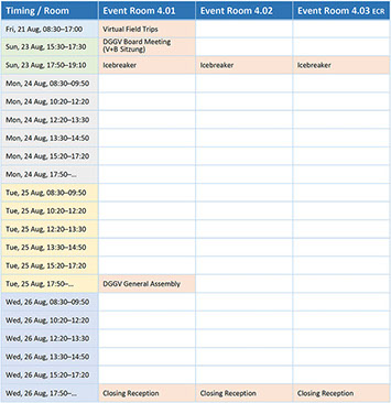
NEW: Tuesday, 25 August 2020, 12:20–13:20 h, Room 4.03
by J. L. Iris Arndt & Lisa Preussner
Goethe University Frankfurt, Germany & GeStEIN e.V., Germany
The ECR room (Room 4.03) is a place for students (BSc, MSc, PhD) and postdocs to meet and exchange information or to relax between sessions. It will be at your disposal during the whole conference. If you have questions for your fellow ECRs or would like to launch an ad-hoc session or just want to start a fun ECR activity, feel free to use this room. We encourage you to participate in shaping the ECR space by contributing your own ideas. If you have any questions regarding the realisation of an idea or a contribution, you are welcome to contact us.
Our ECR social event will take place on Monday evening at 19:00 h (bring your own drinks).
It offers you the opportunity to get together in small groups and talk about some of your favourite topics, such as communiCATion, BEEReaucracy and FUNding.
We look forward to seeing you at GeoUtrecht 2020,
Iris and Lisa
Publishing 101: How to write a book in Earth Sciences,
Geography or Environmental Sciences
Tuesday 25 August 2020, 11:00 – 11:45 h (incl. Q&A), Room 4.01
by Annett Buettner, Springer
Keen to learn more about our Earth Sciences, Geography & Environmental Sciences book publishing program?
You'll hear from Dr. Annett Buettner, a publishing editor of our global team of book publishing editors covering the fields of Earth Sciences, Geography & Environmental Sciences at Springer.
Our live webinar is free to attend and includes time for Q&As at the end of each session.
Case study - Applications of virtual reality in Geoscience: Geological field trip in virtual reality to the Eagle Ford Shale in Texas
Tuesday 25 August 2020, 13:30 – 14:50 h, Room 4.01
by Claudia Ruiz-Graham, CEO & Founder Imaged Reality, & Patricio Desjardins, Regional Geologist, North America, Shell
Patricio Desjardins will be taking us to a fantastic virtual field trip in 3DGaia, to the Eagle Ford Shale in Texas. Patricio is a Senior Regional geologist, expert in Unconventional Reservoirs in Shell, based in Houston. 3DGaia is a virtual reality platform for Geoscience, developed by Imaged Reality.
The field trip will take us through key locations of the Eagle Ford, integrating different subsurface data sets from basin scale to the pore scale. We will demonstrate remote collaboration in Geoscience, using virtual reality. This project was part of a pilot developed jointly by Shell and Imaged Reality.
Field trips are essential for geologists and engineers to develop interpretation skills and to get a sense of scale. Unfortunately, attendance to field trips has become less frequent due to cost, with only a handful of team members attending a field trip once or twice a year. Sometimes access to key outcrop analogues can be difficult or too hazardous. COVID-19 has made attendance to field trips even more challenging.
Remote collaboration in virtual reality provides a valuable alternative. In virtual reality, the user is placed in the digital and surrounded by data in the 3D space. This immersive experience increases cognition, speed of analysis and retention. One of the key advantages of adopting Virtual Reality to support learning is that entire teams can have access to areas that would normally be too hazardous or too expensive to reach. Virtual reality also makes geological field trips more inclusive, giving the opportunity for people with disabilities to attend more field trips. Virtual reality also improves knowledge capture, by creating the option of field trip repeatability. This technology has a wide range of applications in subsurface learning, reservoir characterisation, environmental assessments, infrastructure planning, etc. Users have the ability to ‘fly’ over outcrops or ‘walk’ along these at real scale.
3DGaia is the first in virtual reality platform for immersive learning and remote collaboration in Geoscience. For more information please get in touch at info@imagedreality.com.
DGGV General Assembly 2020 (DGGV-Mitgliederversammlung 2020)
Tuesday, 25 August 2020, 17:50 – 19:10 h, Room 4.01
 EarlyCareerResearchers(ECR) -------> .separat room: – not open to the public9:30–12:00 PythonImaged Reality11–11:45 Publishing 101ECR Event


